2.15. VIIRS
- Description
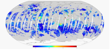
Visible Infrared Imaging Radiometer Suite (VIIRS) This instrument is on a polar-orbiting satellite providing global observations related to the atmosphere, oceans, and Earth’s surface. This information is focused on aerosol optical thickness (other VIIRS products are available).
Sample image
- Recommended use
Evaluating aerosol properties with remotely-sensed data
- File format
NetCDF
- Location of data
VIIRS Atmosphere: https://earthdata.nasa.gov/earth-observation-data/near-real-time/download-nrt-data/viirs-a-nrt
VIIRS Land: https://earthdata.nasa.gov/earth-observation-data/near-real-time/download-nrt-data/viirs-nrt
- Access restrictions
Requires a free Earthdata account
- Spatial resolution, grid, or coverage
Global coverage via polar orbiting swaths, with approximately 1 pass per day per given location near the equator
At-nadir resolution of 6 km x 6 km
- Temporal resolution
6 min
- Starting and/or ending dates
For Level 2 Dust AOD: 1 March 2012-Present
- Data latency
147 min
- Variables available
Aerosol optical thickness at 550 nm over land, ocean, and land/ocean
- METplus Use Cases
Link to METplus Use Cases for this dataset.
- Keywords
Note
Current Dataset: VxDataVIIRS
Note
Data Labels: DataTypeGridded, DataLevelSatellite, DataProviderNASA, DataApplicationShortRange, DataApplicationMediumRange
